Order these records by:
Browse Collection › LC Subject Heading › 23 records found where LC Subject Heading is Durham (N.C.) -- Maps -- 20th century | ||
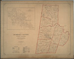 | Map of Durham County, North Carolina prepared by the direction of the County Commissioners from actual surveys This 1920 map provides two views of Durham County. One view delineates the school districts in Durham County and indicates which schools served white or black pupils. It also identifies Mangum, Lebanon, Durham, Oak Grove, Carr, Patterson, and Cedar Fork townships and provides locations for cemeteries and roads. Another view labelled Cities of East and West Durham identifies street names for areas that are now customarily referred to as Old West Durham, including the Ninth Street business district, Trinity Park, Trinity Heights, Walltown (portion), Duke University (East Campus), Old North Durham, Downtown Durham and Fayetteville Street (Hayti), West End, Morehead Hill (portion), Edgemont and Morning Glory, Cleveland-Holloway Street, East End, East Durham (portion). | |
 | Map of Durham, East and West Durham, N.C. A 1924 Durham Chamber of Commerce map depicting schools, mills, factories, and cemeteries in Durham. This map contains information pertaining to neighborhoods now commonly referred to as: West End, Lyon Park, West Durham (area surrounding Erwin Mills), Pearl Cotton Mills Village, Duke University (East Campus), Trinity Heights, Walltown, Trinity Park, Old North Durham, Morehead Hill, Duke Park, Downtown Durham (Central Business District), Cleveland-Holloway Street, East End, East Durham (portion), Edgemont and Morning Glory near the Golden Belt Manufacturing Company, Hayti. The map identifies street names and the location of hydrants, fire alarm boxes and fire stations. | |
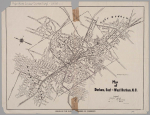
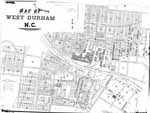 | Map of West Durham, N.C. Civil engineer C.M. Miller drew this detailed map of West Durham, North Carolina in 1910. He identifies street names for an area which is today largely associated with the Old West Durham neighborhood, Erwin Road and Duke's Central campus. The map identifies structures at the Erwin Mills and the size of homes owned by the textile company. It also indicates the location of churches and schools and identifies the names of some property owners. Scale 150 feet to the inch or [ca. 1:1800]. | |
 | Durham, North Carolina / Department of Public Works/ 1930 This map of the city of Durham, North Carolina provides information about street names as well as the diameter and location of sewer lines in 1930. | |
 | Map of Durham, N.C. showing sewer system T.N. Thaxton penned this map of the city of Durham, North Carolina sometime in the 1920s. It provides information about street names as well as the diameter and location of sewer lines in the early 1920s. Also includes names and locations of churches and schools, railroad lines, hospitals, and cemeteries. Scale: 1” = 400 feet or [1:4,800]. | |
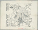
 | Durham, North Carolina / Department of Public Works/ 1951 This map of Durham, North Carolina, created by the Department of Public Works, appears to have been modified between its initial publication in 1948 and 1951. The legend indicates that color annotations were introduced in 1951 which help the user distinguish between “highway system streets” (marked in black) and “streets conforming to the requirements of chapter 260 of the 1951 Session Laws (marked in red). There are three dates on this map: May 1948 which is crossed out, November 10, 1950, and July 1951. The map provides street names as well as an index to streets within the city of Durham, North Carolina a list of schools with identifying markers and other sites including parks, hotels, fire houses, government buildings and libraries. | |
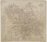
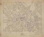
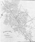 | Durham, N.C. and Suburbs This 1914 map of Durham, North Carolina provides details on the town of Durham and the suburban regions of West Durham and East Durham. The map delineates the town's corporate limits, identifies the name and location of schools, some manufacturers, and railroad lines. The map also provides street names for areas that are now customarily referred to as Old West Durham, including the Ninth Street business district, Trinity Park (portion), Trinity Heights, Walltown (portion), Duke University (East Campus), Old North Durham, Downtown Durham and Fayetteville Street (Hayti), West End, Morehead Hill (portion), Edgemont and Morning Glory, Cleveland-Holloway Street, East End, East Durham (portion). Scale: 800 feet per inch. | |
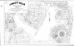 | Map of Forest Hills/ Durham, N.C. Owned by New Hope Realty Co. This map drawn by E.H. Copley in 1927 provides a detailed rendering of individual lots owned by the New Hope Realty Company in Forest Hills, Durham, N.C. and their measurements as they were recorded in plot book 6 at the Registrar of Deeds office. The map also provides names of streets. Scale 1" = 100 feet. | |
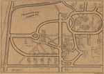 | Trinity College/Durham, N.C. W.P. Budd's map of the Trinity College, Durham, North Carolina identifies key structures and indicates where they stood on campus in 1902. The map includes the location of the chapel, library, dormitories, recreational areas, and stables as well as the homes of professors John Spender Bassett, William I. Cranford, Edwin Mims, William H. Pegram, A. H. Merritt, M. J. Edwards, Robert L. Flowers, and President John C. Kilgo. Additionally, the map shows the location of Watts Hospital and Trinity Park School as well as railroad and streetcar lines. Some of the homes illustrated on this map were later moved to the eastern side of Buchanan Avenue, in the Trinity Park neighborhood. | |
 | Durham, North Carolina: Annexation Map The base of this annotated street map was first produced by the Department of Transportation and Utilities, Durham, N.C. in 1979. From the 1980s to 2001, two employees of Durham's Department of Public Works developed this annexation map to illustrate the City of Durham's growth from 1890 to 2001. Pen and ink notations demarcate where the city limits stood in 1890, 1901, 1925, 1957, 1960, and 1966. A color legend indicates when the city added parcels of land between 1970 and 2000. The map provides information the size of parcels, name of developer or development and date of annexation. The map was developed by Lee Ribet and later updated by Tina Raneri, both employees of the Department of Transportation and Utilities, later known as the Department of Public Works. Scale 1 inch = 1600 feet or [ca. 1:19,200]. | |
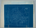 | Sketch drawing, Durham, N.C. Jan. 10, 1907. Blueprint map of Durham, North Carolina drawn in 1907. Shows corporation line, street names, and railroads. Identifies the locations of a few schools, mills, and Trinity College. Scale about 800 ft = 1 inch or [ca. 1:9600]. | |
 | Durham, North Carolina This 1925 Durham, North Carolina map produced by the Department of Public Works provides information on streets and the layout of railroad lines in the city of Durham. The map contains annotations in red pencil. Scale [ca. 1:9,500]. | |
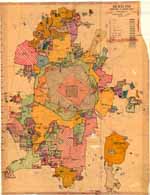
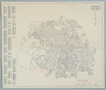
 | Durham, N.C . 1930 This map of Durham bears no publisher or date of publication. Duke University Library cataloguers ascribed 1930 as the date of publication. Its most noticeable features are the sixteen districts with black circles labeled "Court House," "Hunt's Store," "Brady's Shop" etc. This map bears some similarities to maps that were used later in the 20th century to indicate voting districts in the town of Durham. | |
 | Durham, North Carolina This map published by the Durham (N.C.). Dept. of Public Works in 1937 shows street names, their location and delineates the city's corporate limits. The map also indicates the location of railroad lines and includes an index to street names. | |
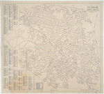
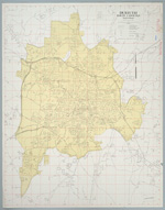
 | Durham, North Carolina This 1937 map published by the Durham, N.C. Dept. of Public Works demarcates "residential and business streets--white" from those that were "residential and business streets--negro." The map identifies the location of "white" and "negro" summer playgrounds, park centers, and community buildings. It also shows the location of incinerators and fire stations. The map also provides and index to streets with their locations. Scale [ca. 1:35,000]. | |
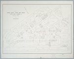 | Occupancy map, business section Durham, North Carolina This 1972 map created by the Allenton Realty and Insurance Company identifies the types of businesses that occupied commercial space in the central business district of Durham, North Carolina. Th map highlights a geographic area that includes "Five Points" and is bounded by Peabody Street, Roxboro Road, Morgan Street and the "West Loop." Scale [ca. 1:1,150] | |
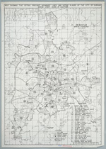
 | Durham, North Carolina This 1945 map produced by the Department of Public Works (dated July 1, 1945) contains a listing of streets and an index to city resources such as the post office, court house, parks, hospitals, libraries, U.S.O. buildings, and schools. Scale [ca. 1:10,000]. | |
 | Durham, North Carolina This street map of Durham, North Carolina was published in 1948. Two years later, an unknown annotator used the map to illustrate the effect an atomic bomb blast would have on the city of Durham. The map contains several typewritten notes which predict the potential damage to buildings and the populations. | |
 | Durham, North Carolina The Department of Public Works produced this map of Durham, North Carolina in 1957. It contains an index to streets and a listing of places of "public interest" including the post office, court house, parks, hospitals, libraries, U.S.O. buildings, schools and colleges. The map bears red pencil marking by an unknown annotator. Scale 2000 feet per inch or [ca. 1:24,000]. | |
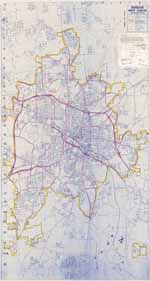
 | Durham, North Carolina The Department of Public Works published this map of the City of Durham, North Carolina in 1967. It delineates the "city limit line" identifies railroad lines and distinguishes "highway system streets," "streets not opened to traffic," "Duke University streets," Interstate Highways, U.S. Highways and State Highways. The reverse side of the map provides an index to city streets. Scale 2000 feet per inch or [1:24,000]. | |
 | Durham, North Carolina : map showing the voting precinct boundary lines and voting places of the city of Durham The Durham County (N.C.) Board of Elections published this map of the City of Durham, North Carolina in 1975. It delineates the "city limit line" identifies railroad lines and distinguishes "highway system streets," "streets not opened to traffic," "Duke University streets," Interstate Highways, U.S. Highways and State Highways. The reverse side of the map provides an index to city streets. Additionally, the map provides a list of precincts and identifies the location of schools and fire stations within the city limits. Scale [1:28,000] | |
 | Durham North Carolina Durham's Department of Transportation and Utilities produced this 1983 map in an effort to comply with the Powell Bill. This map contains an affidavit from engineer Kenneth E. Wright listing the exact miles of local roads and state highway roads. The map indicates that the City of Durham contained just over 484 miles of paved and unpaved streets in 1983. Public Works officials submitted this map to the North Carolina Department of Transportation in order to obtain funds for the maintenance of local roads under the "Powell Bill." | |
 | City of Durham, North Carolina / Powell Bill Map F.Y. 1998-1999 The City of Durham produced this 1999 map in an effort to comply with the Powell Bill. This map demarcates the city line and identifies city system streets, private streets, 1997-1998 “city accepted streets,” dirt streets, interstate highways, United States highways, and state highway roads. City officials submitted this map to the North Carolina Department of Transportation in order to obtain funds for the maintenance of local roads under the "Powell Bill." The map contains an affidavit by engineer Richard Lee Murphy attesting to the validity of the data. | |
digitaldurham@duke.edu · About this site · Copyright © 2001 - 2006. Trudi J. Abel. All Rights Reserved.
The copyright interest in the material in this digital collection has not been transferred to the Digital Durham project. These text and images may not be used for any commercial purpose without the permission of the David M. Rubenstein Rare Book & Manuscript Library and the Digital Durham Project. Copyright permission for subsequent uses is the responsibility of the user.