Browse Collection › Maps › Durham, North Carolina: Annexation Map
|
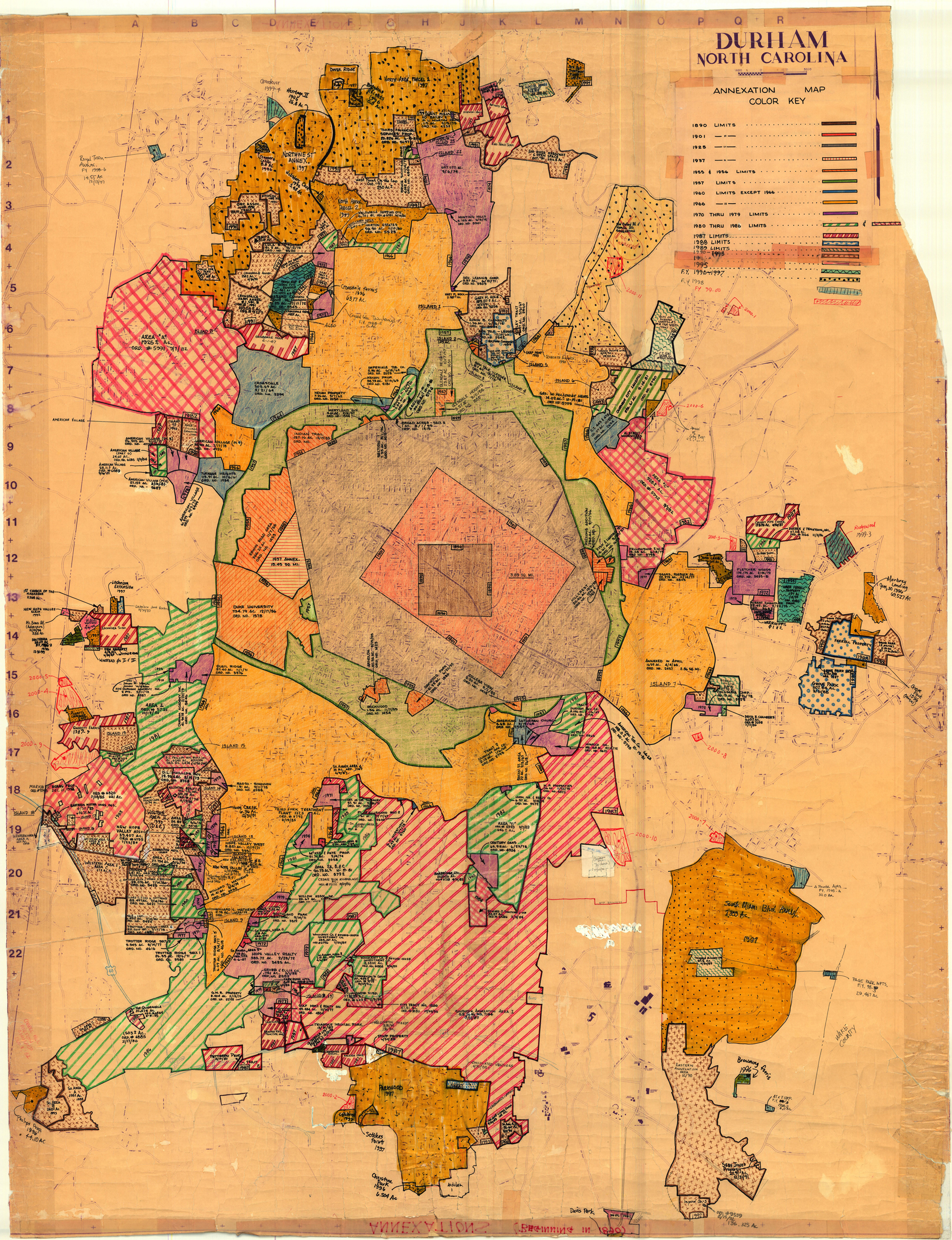
Page 1/1 Durham, North Carolina: Annexation Map Creator(s): Durham (N.C.). Department of Public Works, Publisher Date: 2000 Description: The base of this annotated street map was first produced by the Department of Transportation and Utilities, Durham, N.C. in 1979. From the 1980s to 2001, two employees of Durham's Department of Public Works developed this annexation map to illustrate the City of Durham's growth from 1890 to 2001. Pen and ink notations demarcate where the city limits stood in 1890, 1901, 1925, 1957, 1960, and 1966. A color legend indicates when the city added parcels of land between 1970 and 2000. The map provides information the size of parcels, name of developer or development and date of annexation. The map was developed by Lee Ribet and later updated by Tina Raneri, both employees of the Department of Transportation and Utilities, later known as the Department of Public Works. Scale 1 inch = 1600 feet or [ca. 1:19,200]. Source: Durham, (N.C.). Department of Public Works Notes: The original map is on a sheet of paper measuring approximately 54 x 42 inches. Library of Congress Subject Headings: Durham (N.C.) -- History Real estate development -- North Carolina -- Durham County Real property -- North Carolina -- Durham -- Maps Durham County (N.C.) -- History -- Maps Durham (N.C.) -- Maps -- 20th century Geographic Term: Durham (N.C.) |
digitaldurham@duke.edu · About this site · Copyright © 2001 - 2006. Trudi J. Abel. All Rights Reserved.
The copyright interest in the material in this digital collection has not been transferred to the Digital Durham project. These text and images may not be used for any commercial purpose without the permission of the David M. Rubenstein Rare Book & Manuscript Library and the Digital Durham Project. Copyright permission for subsequent uses is the responsibility of the user.