Order these records by:
Browse Collection › LC Subject Heading › 17 records found where LC Subject Heading is Streets -- North Carolina -- Durham | ||
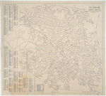
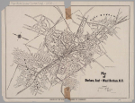 | Map of Durham, East and West Durham, N.C. A 1924 Durham Chamber of Commerce map depicting schools, mills, factories, and cemeteries in Durham. This map contains information pertaining to neighborhoods now commonly referred to as: West End, Lyon Park, West Durham (area surrounding Erwin Mills), Pearl Cotton Mills Village, Duke University (East Campus), Trinity Heights, Walltown, Trinity Park, Old North Durham, Morehead Hill, Duke Park, Downtown Durham (Central Business District), Cleveland-Holloway Street, East End, East Durham (portion), Edgemont and Morning Glory near the Golden Belt Manufacturing Company, Hayti. The map identifies street names and the location of hydrants, fire alarm boxes and fire stations. | |
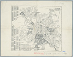
 | Durham, North Carolina / Department of Public Works/ 1951 This map of Durham, North Carolina, created by the Department of Public Works, appears to have been modified between its initial publication in 1948 and 1951. The legend indicates that color annotations were introduced in 1951 which help the user distinguish between “highway system streets” (marked in black) and “streets conforming to the requirements of chapter 260 of the 1951 Session Laws (marked in red). There are three dates on this map: May 1948 which is crossed out, November 10, 1950, and July 1951. The map provides street names as well as an index to streets within the city of Durham, North Carolina a list of schools with identifying markers and other sites including parks, hotels, fire houses, government buildings and libraries. | |
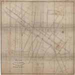
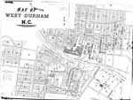 | Map of West Durham, N.C. Civil engineer C.M. Miller drew this detailed map of West Durham, North Carolina in 1910. He identifies street names for an area which is today largely associated with the Old West Durham neighborhood, Erwin Road and Duke's Central campus. The map identifies structures at the Erwin Mills and the size of homes owned by the textile company. It also indicates the location of churches and schools and identifies the names of some property owners. Scale 150 feet to the inch or [ca. 1:1800]. | |
 | Durham, North Carolina / Department of Public Works/ 1930 This map of the city of Durham, North Carolina provides information about street names as well as the diameter and location of sewer lines in 1930. | |
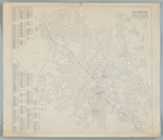 | Durham, North Carolina This map published by the Durham (N.C.). Dept. of Public Works in 1937 shows street names, their location and delineates the city's corporate limits. The map also indicates the location of railroad lines and includes an index to street names. | |
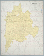
 | Durham, North Carolina This 1937 map published by the Durham, N.C. Dept. of Public Works demarcates "residential and business streets--white" from those that were "residential and business streets--negro." The map identifies the location of "white" and "negro" summer playgrounds, park centers, and community buildings. It also shows the location of incinerators and fire stations. The map also provides and index to streets with their locations. Scale [ca. 1:35,000]. | |
 | Durham, North Carolina This 1925 Durham, North Carolina map produced by the Department of Public Works provides information on streets and the layout of railroad lines in the city of Durham. The map contains annotations in red pencil. Scale [ca. 1:9,500]. | |
 | Plan of the Town of Durham Showing Pipe Distribution of the Durham Water Company This map provides details of street names within the town of Durham and indicates the diameter of water pipes and location of hydrants as of 1887. Scale: 200 feet per inch or [1:2,400]. | |
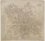
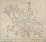
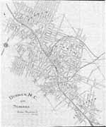 | Durham, N.C. and Suburbs This 1914 map of Durham, North Carolina provides details on the town of Durham and the suburban regions of West Durham and East Durham. The map delineates the town's corporate limits, identifies the name and location of schools, some manufacturers, and railroad lines. The map also provides street names for areas that are now customarily referred to as Old West Durham, including the Ninth Street business district, Trinity Park (portion), Trinity Heights, Walltown (portion), Duke University (East Campus), Old North Durham, Downtown Durham and Fayetteville Street (Hayti), West End, Morehead Hill (portion), Edgemont and Morning Glory, Cleveland-Holloway Street, East End, East Durham (portion). Scale: 800 feet per inch. | |
 | Durham, North Carolina This 1945 map produced by the Department of Public Works (dated July 1, 1945) contains a listing of streets and an index to city resources such as the post office, court house, parks, hospitals, libraries, U.S.O. buildings, and schools. Scale [ca. 1:10,000]. | |
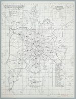
 | Durham, North Carolina The Department of Public Works produced this map of Durham, North Carolina in 1957. It contains an index to streets and a listing of places of "public interest" including the post office, court house, parks, hospitals, libraries, U.S.O. buildings, schools and colleges. The map bears red pencil marking by an unknown annotator. Scale 2000 feet per inch or [ca. 1:24,000]. | |
 | Durham, North Carolina The Department of Public Works published this map of the City of Durham, North Carolina in 1967. It delineates the "city limit line" identifies railroad lines and distinguishes "highway system streets," "streets not opened to traffic," "Duke University streets," Interstate Highways, U.S. Highways and State Highways. The reverse side of the map provides an index to city streets. Scale 2000 feet per inch or [1:24,000]. | |
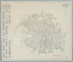
 | Durham, North Carolina : map showing the voting precinct boundary lines and voting places of the city of Durham The Department of Public Works published this map of the City of Durham, North Carolina in 1970. It delineates the "city limit line" identifies railroad lines and distinguishes "highway system streets," "streets not opened to traffic," "Duke University streets," Interstate Highways, U.S. Highways and State Highways. The reverse side of the map provides an index to city streets. Additionally, the map provides a list of precincts and identifies the location of schools and fire stations within the city limits. Scale [ca. 1:28,000]. | |
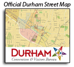 | Official Online Interactive Street Map of Durham, North Carolina Official Online Interactive Street Map of Durham produced by Navteq and the Durham Convention & Visitors Bureau. First released to the public in 2008, the Bureau now provides several different digital maps. Access the digital maps from the Convention & Visitors Bureau. | |
 | Durham North Carolina Durham's Department of Transportation and Utilities produced this 1983 map in an effort to comply with the Powell Bill. This map contains an affidavit from engineer Kenneth E. Wright listing the exact miles of local roads and state highway roads. The map indicates that the City of Durham contained just over 484 miles of paved and unpaved streets in 1983. Public Works officials submitted this map to the North Carolina Department of Transportation in order to obtain funds for the maintenance of local roads under the "Powell Bill." | |
 | City of Durham, North Carolina / Powell Bill Map F.Y. 1998-1999 The City of Durham produced this 1999 map in an effort to comply with the Powell Bill. This map demarcates the city line and identifies city system streets, private streets, 1997-1998 “city accepted streets,” dirt streets, interstate highways, United States highways, and state highway roads. City officials submitted this map to the North Carolina Department of Transportation in order to obtain funds for the maintenance of local roads under the "Powell Bill." The map contains an affidavit by engineer Richard Lee Murphy attesting to the validity of the data. | |
 | Map of Durham, N.C. showing sewer system T.N. Thaxton penned this map of the city of Durham, North Carolina sometime in the 1920s. It provides information about street names as well as the diameter and location of sewer lines in the early 1920s. Also includes names and locations of churches and schools, railroad lines, hospitals, and cemeteries. Scale: 1” = 400 feet or [1:4,800]. | |
digitaldurham@duke.edu · About this site · Copyright © 2001 - 2006. Trudi J. Abel. All Rights Reserved.
The copyright interest in the material in this digital collection has not been transferred to the Digital Durham project. These text and images may not be used for any commercial purpose without the permission of the David M. Rubenstein Rare Book & Manuscript Library and the Digital Durham Project. Copyright permission for subsequent uses is the responsibility of the user.