Browse Collection › Maps › Official Online Interactive Street Map of Durham, North Carolina
|
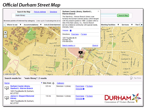
Page 1/1 Official Online Interactive Street Map of Durham, North Carolina Creator(s): Durham Convention and Visitors Bureau, Publisher Navteq, Author Date: 2009 Description: Official Online Interactive Street Map of Durham produced by Navteq and the Durham Convention & Visitors Bureau. First released to the public in 2008, the Bureau now provides several different digital maps. Access the digital maps from the Convention & Visitors Bureau. Source: Durham Convention and Visitors Bureau Library of Congress Subject Headings: Streets -- North Carolina -- Durham Durham (N.C.) -- Maps -- 21st century Geographic Term: Durham (N.C.) |
digitaldurham@duke.edu · About this site · Copyright © 2001 - 2006. Trudi J. Abel. All Rights Reserved.
The copyright interest in the material in this digital collection has not been transferred to the Digital Durham project. These text and images may not be used for any commercial purpose without the permission of the David M. Rubenstein Rare Book & Manuscript Library and the Digital Durham Project. Copyright permission for subsequent uses is the responsibility of the user.