Order these records by:
Browse Collection › LC Subject Heading › 14 records found where LC Subject Heading is Real estate development -- North Carolina -- Durham County | ||
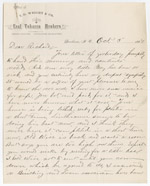
 | Letter from Thomas D. Wright to Richard Harvey Wright, September 29, 1887 Thomas D. Wright acknowledges a letter from his brother, Richard Harvey Wright. Thomas notes that public concerns about frost damage on tobacco plants in North Carolina seem unwarranted. He believes this is the best crop of tobacco since the Civil War. He discusses real estate developments and the cost of land being sold by Tilly near Alston Avenue. Thomas closes with an update on the construction of Richard's new home. | |
 | Letter from Thomas D. Wright to Richard Harvey Wright, October 03, 1887 Thomas expresses concern for Richard's daughter, Little May, who is ill. He updates his brother on the work that Linthicum is doing to build a house for Richard Harvey Wright. He also notes that a new Building and Loan Association plans to build homes on property east of Alston Avenue. | |
 | Letter from Robert I. Rogers to Richard Harvey Wright, July 26, 1890 Robert Rogers, secretary and treasurer for Durham Land and Security, writes to Richard Harvey Wright about the renewal of the graded school contracts. He states that William Guthrie authorized the contract. | |
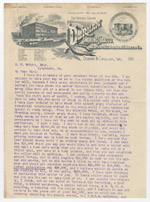 | Letter from Julian S. Carr to Richard Harvey Wright, August 06, 1890 Julian S. Carr, President of Durham Smoking Tobacco and Blackwell's Durham Tobacco Co., gives Richard Harvey Wright his vision to develop Durham and make more money. | |
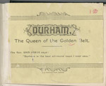 | Durham, the queen of the golden belt An pamphlet created by Durham Consolidated Land and Improvement Company to promote investment in businesses and real estate in Durham, North Carolina. Includes three lithographs of buildings in Durham: Main Building at Trinity College; West End Cotton Factory; and Wescarr Knitting Mill. Durham is described as a sophisticated town with well-developed industrial, commercial, and residential districts for: plants, mills, factories, railroad stations and tracks, banking facilities, schools, churches, and colleges. | |
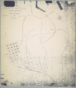
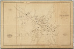 | Gray's new map of Durham, 1881 This cadastral map from 1881 depicts buildings, street names, businesses, property owners, and railroads in Durham, North Carolina. Scale 350 feet = 1 inch or [ca. 1:4,200]. | |
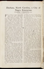 | Durham, North Carolina, a city of Negro enterprises Booker T. Washington, principal of Tuskegee Institute, penned this essay in 1911 for the illustrated magazine, Independent. Washington, recounts his travels to Durham and gives his observations about race relations in Durham. Washington discusses the economic and cultural contributions of many prominent members of the African American community including: Richard B. Fitzgerald, Aaron M. Moore, Richard E. Clegg, John Merrick, and Charles Clinton Spaulding. He devotes much of his analysis to the economic development of the black community in a place that he dubbed, “City of Negro Enterprises.” | |
 | Letter from N. O. Wilkinson to Mattie Logan Southgate, January 27, 1880 N. O. Wilkinson sends this letter to her young neighbor Mattie Logan Southgate, a student at the Wesleyan Female Institute in Staunton, Virginia. Mrs. Wilkinson sends news about her children, Willie, Minnie, and Tommie. Mattie's sister, Annie Southgate spent the day with Mrs. Wilkinson's daughter, Willie. N. O. Wilkinson reports the activities of Durham's young people over Christmas and notes the construction activity in town. She mentions her son's recent hunting trip and reminisces about her school days at Greensboro College. Mrs. Wilkinson closes with a request that Mattie's sister Lessie send her news from school. | |
 | Map of the town of North Durham: property of B. L. Duke and its relative position to Durham, North Carolina An 1890 map showing the property owned by Brodie Leonidas Duke in Durham, North Carolina, just east of Trinity College, in an area now identified as Trinity Park. The map also provides names of downtown streets, shows the location of Bobbin & Shuttle Mills, fertilizer factory, cotton factory and railroad lines. Scale 400 feet to 1 inch or [ca.1:4800]. | |
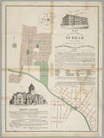 | Map of the town of Durham, North Carolina:showing the property of the Durham Consolidated Land and Improvement Company This 1890 map published by the Durham Consolidated Land & Improvement Company indicates its property holdings north and west of Trinity College, Durham, North Carolina, in areas now known as Trinity Heights, Walltown, and Old West Durham. Contains an advertisement with illustration promoting Trinity College as well as a letter by Richard H. Wright, secretary of the Company, extolling the virtues of Durham's business climate. In 1890, the Durham Consolidated Land & Improvement Company published this map to indicate its property holdings north and west of Trinity College in an area now known as Trinity Heights, Walltown, and Old West Durham. The map also provides some information about streets near the Blackwell Tobacco Factory, now Downtown Durham. It also features an advertisement promoting Trinity College as well as the virtues of Durham's business climate. | |
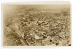 | Aerial photograph of Durham looking toward the Northwest This aerial view of downtown Durham was taken prior to the completion of the Washington Duke Hotel (ciirca 1925). In the foreground on Main Street are the First Presbyterian Church and Durham County Courthouse. The view also shows Union Station, Liggett & Myers and Imperial Tobacco. Durham High School and the Pearl Mill Village are visible in the background. | |
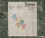 | Sanborn Fire Insurance Map, Durham, North Carolina, 1888 (Google Earth Overlay) Beta Using the Google Earth web application, we have created semi-transparent images from the original set of Fire Insurance Map of 1888 and placed these over satellite imagery of present-day Durham. Because of a paucity of information of some buildings presented on pages 6 and 7, we provide an approximate location for the Bobbin and Shuttle Mill, the Durham Cotton Manufacturing Company, and J.W. Allen's Tobacco Prize House. | |
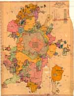 | Durham, North Carolina: Annexation Map The base of this annotated street map was first produced by the Department of Transportation and Utilities, Durham, N.C. in 1979. From the 1980s to 2001, two employees of Durham's Department of Public Works developed this annexation map to illustrate the City of Durham's growth from 1890 to 2001. Pen and ink notations demarcate where the city limits stood in 1890, 1901, 1925, 1957, 1960, and 1966. A color legend indicates when the city added parcels of land between 1970 and 2000. The map provides information the size of parcels, name of developer or development and date of annexation. The map was developed by Lee Ribet and later updated by Tina Raneri, both employees of the Department of Transportation and Utilities, later known as the Department of Public Works. Scale 1 inch = 1600 feet or [ca. 1:19,200]. | |
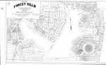 | Map of Forest Hills/ Durham, N.C. Owned by New Hope Realty Co. This map drawn by E.H. Copley in 1927 provides a detailed rendering of individual lots owned by the New Hope Realty Company in Forest Hills, Durham, N.C. and their measurements as they were recorded in plot book 6 at the Registrar of Deeds office. The map also provides names of streets. Scale 1" = 100 feet. | |
digitaldurham@duke.edu · About this site · Copyright © 2001 - 2006. Trudi J. Abel. All Rights Reserved.
The copyright interest in the material in this digital collection has not been transferred to the Digital Durham project. These text and images may not be used for any commercial purpose without the permission of the David M. Rubenstein Rare Book & Manuscript Library and the Digital Durham Project. Copyright permission for subsequent uses is the responsibility of the user.