Order these records by:
Browse Collection › LC Subject Heading › 3 records found where LC Subject Heading is Durham County (N.C.) -- History -- Maps | ||
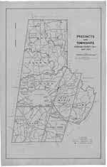 | Precincts and Townships, Durham, N.C., May 1945 This 1945 map prepared for the Durham County Board of Elections delineates boundaries for Mangum, Lebanon, Patterson, Durham, Oak Grove and Cedar Fork townships as well as voting precincts and the location of polling places. This map also indicates the location of churches and schools as well as names of major roads, creeks, rivers and railways. | |
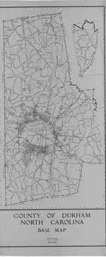 | County of Durham/ North Carolina/ Base Map/ May 1948 This 1948 base map of the County of Durham, North Carolina lists state highways and major roads as well as creeks, rivers, railroad lines and power lines. Scale 1" = 2000 feet. | |
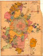 | Durham, North Carolina: Annexation Map The base of this annotated street map was first produced by the Department of Transportation and Utilities, Durham, N.C. in 1979. From the 1980s to 2001, two employees of Durham's Department of Public Works developed this annexation map to illustrate the City of Durham's growth from 1890 to 2001. Pen and ink notations demarcate where the city limits stood in 1890, 1901, 1925, 1957, 1960, and 1966. A color legend indicates when the city added parcels of land between 1970 and 2000. The map provides information the size of parcels, name of developer or development and date of annexation. The map was developed by Lee Ribet and later updated by Tina Raneri, both employees of the Department of Transportation and Utilities, later known as the Department of Public Works. Scale 1 inch = 1600 feet or [ca. 1:19,200]. | |
digitaldurham@duke.edu · About this site · Copyright © 2001 - 2006. Trudi J. Abel. All Rights Reserved.
The copyright interest in the material in this digital collection has not been transferred to the Digital Durham project. These text and images may not be used for any commercial purpose without the permission of the David M. Rubenstein Rare Book & Manuscript Library and the Digital Durham Project. Copyright permission for subsequent uses is the responsibility of the user.