Browse Collection › Maps › Precincts and Townships, Durham, N.C., May 1945

|
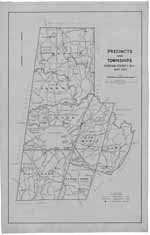
Page 1/1 Precincts and Townships, Durham, N.C., May 1945 Creator(s): Lee, R. E. Jr., Cartographer Durham County (N.C.). Board of Elections., Publisher Date: 1945 Description: This 1945 map prepared for the Durham County Board of Elections delineates boundaries for Mangum, Lebanon, Patterson, Durham, Oak Grove and Cedar Fork townships as well as voting precincts and the location of polling places. This map also indicates the location of churches and schools as well as names of major roads, creeks, rivers and railways. Source: Durham, (N.C.). Department of Public Works Library of Congress Subject Headings: Durham County (N.C.) -- History Durham County (N.C.) -- History -- Maps Election districts -- North Carolina -- Durham County -- Maps Durham County (N.C.) -- Administrative and political divisions -- Maps Durham County (N.C.) -- Maps -- 20th century, LCSH Geographic Term: Durham County (N.C.) |
digitaldurham@duke.edu · About this site · Copyright © 2001 - 2006. Trudi J. Abel. All Rights Reserved.
The copyright interest in the material in this digital collection has not been transferred to the Digital Durham project. These text and images may not be used for any commercial purpose without the permission of the David M. Rubenstein Rare Book & Manuscript Library and the Digital Durham Project. Copyright permission for subsequent uses is the responsibility of the user.