Browse Collection › Maps › Sketch drawing, Durham, N.C. Jan. 10, 1907.

|
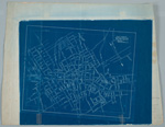
Page 1/1 Sketch drawing, Durham, N.C. Jan. 10, 1907. Date: 1907 Description: Blueprint map of Durham, North Carolina drawn in 1907. Shows corporation line, street names, and railroads. Identifies the locations of a few schools, mills, and Trinity College. Scale about 800 ft = 1 inch or [ca. 1:9600]. Source: Government Documents, Perkins Library, Duke University Dimensions: 34 x 42 cm. Library of Congress Subject Headings: Durham (N.C.) -- Maps -- 20th century Trinity College (Durham, N.C.) Geographic Term: Durham (N.C.) |
digitaldurham@duke.edu · About this site · Copyright © 2001 - 2006. Trudi J. Abel. All Rights Reserved.
The copyright interest in the material in this digital collection has not been transferred to the Digital Durham project. These text and images may not be used for any commercial purpose without the permission of the David M. Rubenstein Rare Book & Manuscript Library and the Digital Durham Project. Copyright permission for subsequent uses is the responsibility of the user.