Order these records by:
Browse Collection › LC Subject Heading › 13 records found where LC Subject Heading is Durham (N.C.) -- Maps -- 19th century | ||
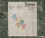
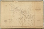 | Gray's new map of Durham, 1881 This cadastral map from 1881 depicts buildings, street names, businesses, property owners, and railroads in Durham, North Carolina. Scale 350 feet = 1 inch or [ca. 1:4,200]. | |
 | Map of Durham County, North Carolina This rudimentary map (circa 1881) shows major roads that connect Chapel Hill to Durham, and Chapel Hill to Hillsboro. Includes major rivers and township boundaries for Cedar Grove, Hillsboro, Little River, Binghams and Chapel Hill in Orange County and, Mangum and Patterson in Durham County. Also delineates Oak Grove and Cedar Fork townships on the western border of Wake County. Includes portions of Tallyho and Dutchville townships in Granville County. Scale [ca. 1: 120,000]. | |
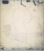 | Map of the town of North Durham: property of B. L. Duke and its relative position to Durham, North Carolina An 1890 map showing the property owned by Brodie Leonidas Duke in Durham, North Carolina, just east of Trinity College, in an area now identified as Trinity Park. The map also provides names of downtown streets, shows the location of Bobbin & Shuttle Mills, fertilizer factory, cotton factory and railroad lines. Scale 400 feet to 1 inch or [ca.1:4800]. | |
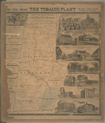 | Map of Durham County, N.C. This 1887 map indicates the location of landowners, churches, quarries, saw mills, creeks, railroads and a coal mine. Includes advertisements for local businesses including the newspaper Tobacco Plant, Seeman Printery, Vaughn & Tenny, druggists and fourteen illustrations of: Morris & Son factory, J.S. Carr’s residence, E.J. Parrish’s residence, Trinity Church, Banner Ware-house, View of Main Street, View of Mangum Street, Durham Hotel (Claiborn), E. Morehead & Co. bankers, Globe warehouse, Durham Cotton mills, Z.I. Lyon & Co.’s tobacco factory, Blackwell’s Co-operative tobacco factory, and W. Duke Sons & Co.’s factory. The map provides the names and boundaries of six Durham County townships including Mangum, Lebanon, Durham, Patterson, Oak Grove, and Cedar Fork. Scale [ca. 1:63,360]. | |
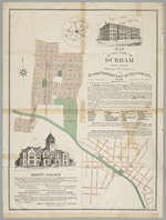 | Map of the town of Durham, North Carolina:showing the property of the Durham Consolidated Land and Improvement Company This 1890 map published by the Durham Consolidated Land & Improvement Company indicates its property holdings north and west of Trinity College, Durham, North Carolina, in areas now known as Trinity Heights, Walltown, and Old West Durham. Contains an advertisement with illustration promoting Trinity College as well as a letter by Richard H. Wright, secretary of the Company, extolling the virtues of Durham's business climate. In 1890, the Durham Consolidated Land & Improvement Company published this map to indicate its property holdings north and west of Trinity College in an area now known as Trinity Heights, Walltown, and Old West Durham. The map also provides some information about streets near the Blackwell Tobacco Factory, now Downtown Durham. It also features an advertisement promoting Trinity College as well as the virtues of Durham's business climate. | |
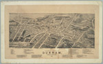 | Bird's-Eye View of the City of Durham, North Carolina, 1891 This 1891 map shows an aerial view of Durham and provides an extensive index to the location of tobacco warehouses, factories, restaurants, groceries, dry goods dealers, churches, and residences located in Durham. Business owners include: Robert I. Rogers, Richard B. Fitzgerald, W. Shelburn, photographer, Q. E. Rawls, dry goods and many others. Also mentioned are the editors of the local newspapers E.C. Hackney of the Durham Recorder, Al Fairweather of the Durham Daily Globe, and J.A. Robinson of the Durham Daily Sun. | |
 | Plan of the Town of Durham Showing Pipe Distribution of the Durham Water Company This map provides details of street names within the town of Durham and indicates the diameter of water pipes and location of hydrants as of 1887. Scale: 200 feet per inch or [1:2,400]. | |
 | Plans and Details of Works of The Durham Water Co. Durham N.C. 1887 This large map contains a series of smaller maps and illustrations which show the means by which Durham residents received water from the Eno River. Included are: "Plans of Storage Reservoir Dam," "Plan of Distributing Reservoir," "Plan of Power and Storage Reservoirs," and the "Pipe Distribution System." This latter map provides details of street names within the Town of Durham and the diameter of water pipes as well as the location of hydrants and gates in 1887. | |
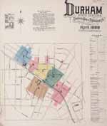 | Sanborn Fire Insurance Map, Durham, North Carolina, 1888 This fire insurance map by the Sanborn Map & Publishing Company provides a detailed look at the commercial buildings that stood within the town limits of Durham, North Carolina in 1888. The map contains an index page to city streets and the location of the county courthouse, jail, churches, manufacturers, tobacco warehouses and prizing establishments, mills, stables, and other enterprises. The map's legend provides details about the construction of the buildings (whether they have been built from stone, brick or wood) as well as details about the number of stories and windows. The map also lists the type of commercial enterprises housed in various structures. For larger businesses, the cartographer details the number of workers employed and describes the establishments’ fire-fighting capabilities. Scale ca. 1" = 50 feet. A georeferenced version of this map is also available on the Digital Durham website. | |
 | Sanborn Fire Insurance Map, Durham, North Carolina, 1888 (Google Earth Overlay) Beta Using the Google Earth web application, we have created semi-transparent images from the original set of Fire Insurance Map of 1888 and placed these over satellite imagery of present-day Durham. Because of a paucity of information of some buildings presented on pages 6 and 7, we provide an approximate location for the Bobbin and Shuttle Mill, the Durham Cotton Manufacturing Company, and J.W. Allen's Tobacco Prize House. | |
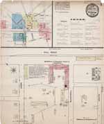 | Sanborn Fire Insurance Map, Durham, North Carolina, 1884 This five-page fire insurance map by the Sanborn Map & Publishing Company provides a detailed look at the commercial buildings that stood at the center of Durham, North Carolina in 1884. The map contains an index page to city streets that identifies the location of churches, tobacco warehouses, and other enterprises. A key to the maps provides details about the construction of the buildings (whether they have been built from stone, brick or wood) as well as details about the number of stories and windows. The maps also list the type of retail enterprises housed in various structures. For larger businesses, the cartographer details the number of workers employed and describes the establishments’ fire-fighting capabilities. Scale ca. 1" = 50 feet or [ca. 1:600]. A georeferenced version of this map is also available on the Digital Durham website. | |
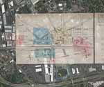 | Sanborn Fire Insurance Map, Durham, North Carolina, 1884 (Google Earth Overlay) Beta Using the Google Earth web application, we have created semi-transparent images from the original set of Fire Insurance Map of 1888 and placed these over satellite imagery of present-day Durham. Because of a paucity of information of some buildings presented on pages 6 and 7, we provide an approximate location for the Bobbin and Shuttle Mill, the Durham Cotton Manufacturing Company, and J.W. Allen's Tobacco Prize House. This fire insurance map by the Sanborn Map & Publishing Company provides a detailed look at the commercial buildings that stood within the town limits of Durham, North Carolina in 1884. The map contains an index page to city streets and the location of the county courthouse, jail, churches, manufacturers, tobacco warehouses and prizing establishments, mills, stables, and other enterprises. A key to the maps provides details about the construction of the buildings (whether they have been built from stone, brick or wood) as well as details about the number of stories a... | |
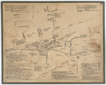 | "This Map of Durham as I remember in 1867-1868. Drawn from memory entirely and no attempt made at correct angles or measurements." Lewis Blount of Abbeville, South Carolina penned this map in 1923. He called it, "This Map of Durham as I remember in 1867-1868. Drawn from memory entirely and no attempt made at correct angles or measurements." He delineates some of the natural features--creeks and springs--major roads, the North Carolina railroad line running through town, of what is now downtown Durham and southwest Durham. He also provides an index to some sixty sites including graveyards, homesteads, churches, black- and white-owned businesses and factories. | |
digitaldurham@duke.edu · About this site · Copyright © 2001 - 2006. Trudi J. Abel. All Rights Reserved.
The copyright interest in the material in this digital collection has not been transferred to the Digital Durham project. These text and images may not be used for any commercial purpose without the permission of the David M. Rubenstein Rare Book & Manuscript Library and the Digital Durham Project. Copyright permission for subsequent uses is the responsibility of the user.