Order these records by:
Browse Collection › LC Subject Heading › 27 records found where LC Subject Heading is Historic buildings -- North Carolina -- Durham | ||
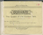 | Durham, the queen of the golden belt An pamphlet created by Durham Consolidated Land and Improvement Company to promote investment in businesses and real estate in Durham, North Carolina. Includes three lithographs of buildings in Durham: Main Building at Trinity College; West End Cotton Factory; and Wescarr Knitting Mill. Durham is described as a sophisticated town with well-developed industrial, commercial, and residential districts for: plants, mills, factories, railroad stations and tracks, banking facilities, schools, churches, and colleges. | |
 | Hand-book of Durham, North Carolina : a brief and accurate description of a prosperous and growing southern manufacturing town This pocket-sized handbook documents the people, businesses, social conditions, and government of Durham, North Carolina, and compares Durham's industrial and social advantages to other cities of the same size. It includes statistical records and information about Durham's government, health, real estate, taxes, buildings, streets, waterworks, fire departments, electric lights and gas, telephones, hotels, hospitals, markets, schools and colleges, churches, lodges, and social clubs. Included are lithographs of Mangum Street and Main Street and depictions of prominent buildings, such as: Bennett Place; Durham County Court House; the Fire House; Hotel Carolina; City Hospital; Durham Graded School; Trinity College's Main Building; Trinity Methodist Church; Main Street Methodist Church; the Presbyterian Church; the First and Second Baptist Church; bank buildings; the factory of the Blackwell Durham Tobacco Co.; Duke Tobacco Factory; and textile factories. Portraits include Isaac N. Link, ma... | |
 | Milestones along the color line. A souvenir of Durham, North Carolina showing the progress of a race Oliver B.Quick created Milestones Along the Color Line. A Souvenir of Durham, North Carolina Showing the Progress of a Race, to show property “owned and controlled exclusively by Negroes in the city of Durham, N.C.” In his preface he noted, “we have selected these [institutions and homes] as evidence of the progress being made by our race group in this section of the South.” The pamphlet contains numerous photographic images of churches, schools, business establishments, private residences and street scenes. | |
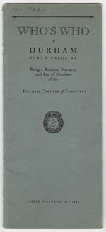 | Who's who in Durham, North Carolina ,being a business directory and list of members of the Durham Chamber of Commerce This 1924 Durham Chamber of Commerce publication contains information about the Chamber and its membership. The pamphlet provides an alphabetical listing of individual members, a classified business directory, and a section of “facts about Durham.” | |
 | Durham, North Carolina : thirty years ago an insignificant village with a population of some five hundred A Durham Chamber of Commerce booklet, published in 1906, which presents a short history of Durham as well as numerous photographic illustrations of educational institutions, churches, manufacturing establishments and street scenes. The pamphlet also includes statistical information about Durham County and its schools. | |
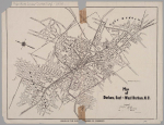
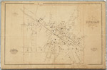 | Gray's new map of Durham, 1881 This cadastral map from 1881 depicts buildings, street names, businesses, property owners, and railroads in Durham, North Carolina. Scale 350 feet = 1 inch or [ca. 1:4,200]. | |
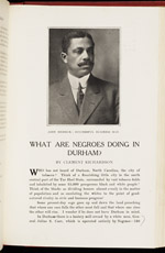 | What are Negroes doing in Durham? Essay by Clement Richardson in the Southern Workman highlighting the achievements of the African American community in Durham in the early 1910s. Richardson focuses on the contributions of black entrepreneurs and professionals including E. R. Merrick, Robert Fitzgerald, Stuart Lynn Warren, John Merrick, Dr. A. M. (Aaron McDuffie), R. H. Clegg, W. G. Pearson, J. S. Scarborough, E. W. Cannady, Dr. F. D. Page, Peyton H. Smith, P. W. Dawkins, Jr. and others. | |
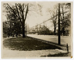
 | Photograph of the Thomas Decatur Jones and Mattie Southgate Jones residence Photograph taken from the front yard of the Thomas Decatur Jones and Mattie Southgate Jones residence at 307 W. Chapel Hill Street, in Durham. | |
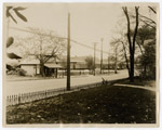
 | Photograph of Chapel Hill Street looking west toward Duke Memorial Church Photograph taken from the front yard of the Thomas Decatur Jones and Mattie Southgate Jones residence at 307 W. Chapel Hill Street in Durham, North Carolina. Duke Memorial United Methodist Church stands on the north side of W. Chapel Hill Street. | |
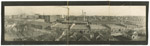
 | Panoramic photograph of Parrish Street in Durham This panoramic view of Parrish Street (circa 1926) features the six-story headquarters of the North Carolina Mutual Life Insurance Company, a company established by black entrepreneurs, John Merrick, Dr. Aaron M. Moore, and Charles Clinton Spaulding. The firm's headquarters (as depicted in this image) was designed by Durham architects Rose and Rose and erected in 1921. Five years later, the building, located at 114-116 Parrish Street, housed the Mechanics and Farmers Bank, North Carolina Mutual Life Insurance Company, Mutual Building & Loan Association, and the Merrick-McDougald-Wilson Company. After North Carolina Mutual Life Insurance Company moved to its new headquarters on Chapel Hill Street in 1965, the old headquarters on Parrish Street was renamed the Mechanics & Farmers Bank building. The right panel of this photograph features the Durham County Courthouse (erected in 1916) and the Union Depot, both designed by Milburn and Heister Company, architects. | |
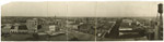
 | Panoramic photograph, American Tobacco factory in Durham looking to the East This panoramic view of Durham, North Carolina shows the factory of the American Tobacco Company, the original home of the W. T. Blackwell & Company enterprise, producer of Bull Durham Smoking Tobacco. This view was shot from the western edge of the factory complex looking eastward over the Washington Building. The image appeared in Durham, North Carolina: A Center of Industry and Education, a publication issued by the Durham Chamber of Commerce in 1926. | |
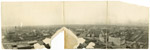 | Panoramic photograph of downtown Durham looking west This panoramic view, taken from the Washington Duke Hotel, captures several landmarks. On the left, at the corner of Blackwell and Pettigrew streets, sits the historic W. T. Blackwell & Company Tobacco Factory, purveyor of Bull Durham tobacco, and part of the American Tobacco Company. The Liggett & Myers plant sits in the center panel near the horizon. The Imperial Tobacco Company and the Durham High School appear in the distance of the right panel. In the foreground on the right, sits the Durham Auditorium (now the Carolina Theatre). Holladay Studios shot the image which appears on p. 10 of the 1926 Durham Chamber of Commerce publication, Durham, North Carolina: A Center of Industry and Education. | |
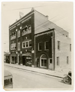
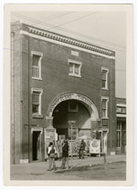 | Photograph of Wonderland Theater in Durham Photograph of the Wonderland Theater, located on the corner of Pettigrew and Ramsey streets. This theater, owned by "movie king" Frederick K. Watkins offered entertainment for Durham's black residents. A poster advertises The Barrier, starring Lionel Barrymore. | |
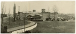 | Photograph of Golden Belt Manufacturing building Photograph of the Golden Belt Manufacturing building with people standing outside. The Durham Chamber of Commerce published this image in their 1926 brochure entitled Durham, North Carolina: A Center of Industry and Education. | |
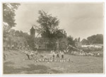 | Photograph of children in playground with ball Durham Chamber of Commerce photograph of children playing on a playground with a ball, on a see-saw, and with other toys. In the background is an advertisement for BC Headache products. | |
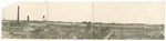 | Panoramic photograph of Erwin Cotton Mills with mill housing Holladay Studio photographed Erwin Cotton Mills and the company's housing for its employees, which is located nearby the mill. | |
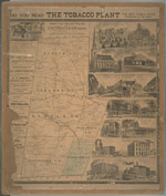 | Map of Durham County, N.C. This 1887 map indicates the location of landowners, churches, quarries, saw mills, creeks, railroads and a coal mine. Includes advertisements for local businesses including the newspaper Tobacco Plant, Seeman Printery, Vaughn & Tenny, druggists and fourteen illustrations of: Morris & Son factory, J.S. Carr’s residence, E.J. Parrish’s residence, Trinity Church, Banner Ware-house, View of Main Street, View of Mangum Street, Durham Hotel (Claiborn), E. Morehead & Co. bankers, Globe warehouse, Durham Cotton mills, Z.I. Lyon & Co.’s tobacco factory, Blackwell’s Co-operative tobacco factory, and W. Duke Sons & Co.’s factory. The map provides the names and boundaries of six Durham County townships including Mangum, Lebanon, Durham, Patterson, Oak Grove, and Cedar Fork. Scale [ca. 1:63,360]. | |
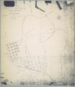 | Map of the town of North Durham: property of B. L. Duke and its relative position to Durham, North Carolina An 1890 map showing the property owned by Brodie Leonidas Duke in Durham, North Carolina, just east of Trinity College, in an area now identified as Trinity Park. The map also provides names of downtown streets, shows the location of Bobbin & Shuttle Mills, fertilizer factory, cotton factory and railroad lines. Scale 400 feet to 1 inch or [ca.1:4800]. | |
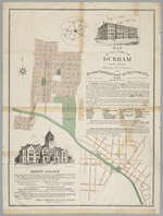 | Map of the town of Durham, North Carolina:showing the property of the Durham Consolidated Land and Improvement Company This 1890 map published by the Durham Consolidated Land & Improvement Company indicates its property holdings north and west of Trinity College, Durham, North Carolina, in areas now known as Trinity Heights, Walltown, and Old West Durham. Contains an advertisement with illustration promoting Trinity College as well as a letter by Richard H. Wright, secretary of the Company, extolling the virtues of Durham's business climate. In 1890, the Durham Consolidated Land & Improvement Company published this map to indicate its property holdings north and west of Trinity College in an area now known as Trinity Heights, Walltown, and Old West Durham. The map also provides some information about streets near the Blackwell Tobacco Factory, now Downtown Durham. It also features an advertisement promoting Trinity College as well as the virtues of Durham's business climate. | |
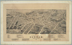 | Bird's-Eye View of the City of Durham, North Carolina, 1891 This 1891 map shows an aerial view of Durham and provides an extensive index to the location of tobacco warehouses, factories, restaurants, groceries, dry goods dealers, churches, and residences located in Durham. Business owners include: Robert I. Rogers, Richard B. Fitzgerald, W. Shelburn, photographer, Q. E. Rawls, dry goods and many others. Also mentioned are the editors of the local newspapers E.C. Hackney of the Durham Recorder, Al Fairweather of the Durham Daily Globe, and J.A. Robinson of the Durham Daily Sun. | |
 | Map of Durham, East and West Durham, N.C. A 1924 Durham Chamber of Commerce map depicting schools, mills, factories, and cemeteries in Durham. This map contains information pertaining to neighborhoods now commonly referred to as: West End, Lyon Park, West Durham (area surrounding Erwin Mills), Pearl Cotton Mills Village, Duke University (East Campus), Trinity Heights, Walltown, Trinity Park, Old North Durham, Morehead Hill, Duke Park, Downtown Durham (Central Business District), Cleveland-Holloway Street, East End, East Durham (portion), Edgemont and Morning Glory near the Golden Belt Manufacturing Company, Hayti. The map identifies street names and the location of hydrants, fire alarm boxes and fire stations. | |
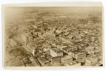 | Aerial photograph of Durham looking toward the Northwest This aerial view of downtown Durham was taken prior to the completion of the Washington Duke Hotel (ciirca 1925). In the foreground on Main Street are the First Presbyterian Church and Durham County Courthouse. The view also shows Union Station, Liggett & Myers and Imperial Tobacco. Durham High School and the Pearl Mill Village are visible in the background. | |
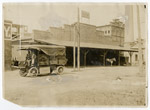 | Photograph of Electric, Ice Plant, Durham Traction Company A 1914 photograph of the Durham Traction Company Light and Power building, in front of which sits a motorized "Electric Truck No. 1," as well as horse-drawn wagons. Richard Harvey Wright was the first president of the company; Julian Shakespeare Carr served as Vice President. | |
 | Photograph of Pender's Grocery Store, 709 Fayetteville Street, Durham, North Carolina This photograph depicts Pender's Stores Co., grocers, and the Hunter Masonic Temple located at 709 Fayetteville Street in the Hayti neighborhood of Durham, North Carolina. Signs in the grocery store window advertise beans, peas, lye and sugar. A gentleman stands in the doorway of the building adjacent to Pender's where the glass windows advertise the offices of Dr. Cordice, physician and surgeon. | |
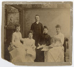 | Photograph of Gilmore Ward Bryant with pupils from Southern Conservatory of Music Portrait of Gilmore Ward Bryant and his students from the Southern Conservatory of Music, Durham, North Carolina. | |
 | Photograph of Chapel Hill Street from the front yard of the Thomas Decatur Jones and Mattie Southgate Jones residence Photograph taken from the front yard of the Thomas Decatur Jones and Mattie Southgate Jones residence at 307 W. Chapel Hill Street, in Durham, looking north towards the railroads tracks and the Walker Warehouse built by the American Tobacco Company in 1897. | |
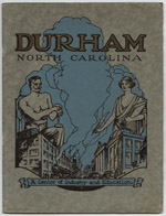 | Durham, North Carolina, a center of education and industry A Durham Chamber of Commerce booklet published in 1926, Durham, North Carolina, a Center of Education and Industry presents the "story of Durham's rise to a self-conscious power in the progress of the New South." Descriptions highlight Durham's crops, manufacturing, churches, businesses, housing and recreational facilities. Includes more than 35 pages of photographs with captions and an architectural rendering of a planned suburb in the Hope Valley area of Durham. | |
digitaldurham@duke.edu · About this site · Copyright © 2001 - 2006. Trudi J. Abel. All Rights Reserved.
The copyright interest in the material in this digital collection has not been transferred to the Digital Durham project. These text and images may not be used for any commercial purpose without the permission of the David M. Rubenstein Rare Book & Manuscript Library and the Digital Durham Project. Copyright permission for subsequent uses is the responsibility of the user.