Order these records by:
Browse Collection › LC Subject Heading › 2 records found where LC Subject Heading is Durham County (N.C.) -- Maps -- 20th century | ||
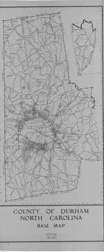 | County of Durham/ North Carolina/ Base Map/ May 1948 This 1948 base map of the County of Durham, North Carolina lists state highways and major roads as well as creeks, rivers, railroad lines and power lines. Scale 1" = 2000 feet. | |
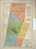 | Map of Durham County, N.C. This map of Durham County, created by C.M. Miller, civil engineer of Salisbury, N.C., dates from the 1910s. It delineates township lines,indicates the locations of landowners' homes, tenant houses, churches, mills, public roads, private roads and "macadam roads." The map also identifies school houses and school district lines. White schools appear to be identified by name, while schools for black students bear the label "col. sch." The map also provides information on rural mail routes for the county. | |
digitaldurham@duke.edu · About this site · Copyright © 2001 - 2006. Trudi J. Abel. All Rights Reserved.
The copyright interest in the material in this digital collection has not been transferred to the Digital Durham project. These text and images may not be used for any commercial purpose without the permission of the David M. Rubenstein Rare Book & Manuscript Library and the Digital Durham Project. Copyright permission for subsequent uses is the responsibility of the user.