Order these records by:
Browse Collection › LC Subject Heading › 2 records found where LC Subject Heading is Durham (N.C.) -- Commerce -- History -- 20th century | ||
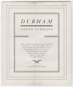 | Durham, North Carolina : thirty years ago an insignificant village with a population of some five hundred A Durham Chamber of Commerce booklet, published in 1906, which presents a short history of Durham as well as numerous photographic illustrations of educational institutions, churches, manufacturing establishments and street scenes. The pamphlet also includes statistical information about Durham County and its schools. | |
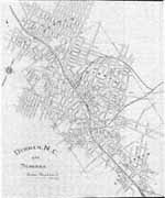 | Durham, N.C. and Suburbs This 1914 map of Durham, North Carolina provides details on the town of Durham and the suburban regions of West Durham and East Durham. The map delineates the town's corporate limits, identifies the name and location of schools, some manufacturers, and railroad lines. The map also provides street names for areas that are now customarily referred to as Old West Durham, including the Ninth Street business district, Trinity Park (portion), Trinity Heights, Walltown (portion), Duke University (East Campus), Old North Durham, Downtown Durham and Fayetteville Street (Hayti), West End, Morehead Hill (portion), Edgemont and Morning Glory, Cleveland-Holloway Street, East End, East Durham (portion). Scale: 800 feet per inch. | |
digitaldurham@duke.edu · About this site · Copyright © 2001 - 2006. Trudi J. Abel. All Rights Reserved.
The copyright interest in the material in this digital collection has not been transferred to the Digital Durham project. These text and images may not be used for any commercial purpose without the permission of the David M. Rubenstein Rare Book & Manuscript Library and the Digital Durham Project. Copyright permission for subsequent uses is the responsibility of the user.