Order these records by:
Browse Collection › LC Subject Heading › 4 records found where LC Subject Heading is Trinity College (Durham, N.C.) | ||
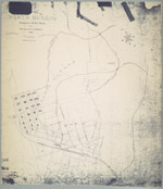 | Map of the town of North Durham: property of B. L. Duke and its relative position to Durham, North Carolina An 1890 map showing the property owned by Brodie Leonidas Duke in Durham, North Carolina, just east of Trinity College, in an area now identified as Trinity Park. The map also provides names of downtown streets, shows the location of Bobbin & Shuttle Mills, fertilizer factory, cotton factory and railroad lines. Scale 400 feet to 1 inch or [ca.1:4800]. | |
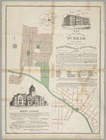 | Map of the town of Durham, North Carolina:showing the property of the Durham Consolidated Land and Improvement Company This 1890 map published by the Durham Consolidated Land & Improvement Company indicates its property holdings north and west of Trinity College, Durham, North Carolina, in areas now known as Trinity Heights, Walltown, and Old West Durham. Contains an advertisement with illustration promoting Trinity College as well as a letter by Richard H. Wright, secretary of the Company, extolling the virtues of Durham's business climate. In 1890, the Durham Consolidated Land & Improvement Company published this map to indicate its property holdings north and west of Trinity College in an area now known as Trinity Heights, Walltown, and Old West Durham. The map also provides some information about streets near the Blackwell Tobacco Factory, now Downtown Durham. It also features an advertisement promoting Trinity College as well as the virtues of Durham's business climate. | |
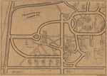 | Trinity College/Durham, N.C. W.P. Budd's map of the Trinity College, Durham, North Carolina identifies key structures and indicates where they stood on campus in 1902. The map includes the location of the chapel, library, dormitories, recreational areas, and stables as well as the homes of professors John Spender Bassett, William I. Cranford, Edwin Mims, William H. Pegram, A. H. Merritt, M. J. Edwards, Robert L. Flowers, and President John C. Kilgo. Additionally, the map shows the location of Watts Hospital and Trinity Park School as well as railroad and streetcar lines. Some of the homes illustrated on this map were later moved to the eastern side of Buchanan Avenue, in the Trinity Park neighborhood. | |
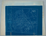 | Sketch drawing, Durham, N.C. Jan. 10, 1907. Blueprint map of Durham, North Carolina drawn in 1907. Shows corporation line, street names, and railroads. Identifies the locations of a few schools, mills, and Trinity College. Scale about 800 ft = 1 inch or [ca. 1:9600]. | |
digitaldurham@duke.edu · About this site · Copyright © 2001 - 2006. Trudi J. Abel. All Rights Reserved.
The copyright interest in the material in this digital collection has not been transferred to the Digital Durham project. These text and images may not be used for any commercial purpose without the permission of the David M. Rubenstein Rare Book & Manuscript Library and the Digital Durham Project. Copyright permission for subsequent uses is the responsibility of the user.