Order these records by:
Browse Collection › LC Subject Heading › 2 records found where LC Subject Heading is Segregation -- North Carolina -- History -- 20th century | ||
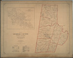 | Map of Durham County, North Carolina prepared by the direction of the County Commissioners from actual surveys This 1920 map provides two views of Durham County. One view delineates the school districts in Durham County and indicates which schools served white or black pupils. It also identifies Mangum, Lebanon, Durham, Oak Grove, Carr, Patterson, and Cedar Fork townships and provides locations for cemeteries and roads. Another view labelled Cities of East and West Durham identifies street names for areas that are now customarily referred to as Old West Durham, including the Ninth Street business district, Trinity Park, Trinity Heights, Walltown (portion), Duke University (East Campus), Old North Durham, Downtown Durham and Fayetteville Street (Hayti), West End, Morehead Hill (portion), Edgemont and Morning Glory, Cleveland-Holloway Street, East End, East Durham (portion). | |
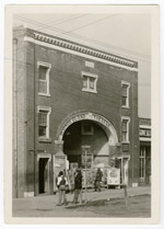 | Photograph of Wonderland Theater in Durham Photograph of the Wonderland Theater, located on the corner of Pettigrew and Ramsey streets. This theater, owned by "movie king" Frederick K. Watkins offered entertainment for Durham's black residents. A poster advertises The Barrier, starring Lionel Barrymore. | |
digitaldurham@duke.edu · About this site · Copyright © 2001 - 2006. Trudi J. Abel. All Rights Reserved.
The copyright interest in the material in this digital collection has not been transferred to the Digital Durham project. These text and images may not be used for any commercial purpose without the permission of the David M. Rubenstein Rare Book & Manuscript Library and the Digital Durham Project. Copyright permission for subsequent uses is the responsibility of the user.