Order these records by:
Browse Collection › LC Subject Heading › 2 records found where LC Subject Heading is Pearl Cotton Mills (Durham, N.C.) | ||
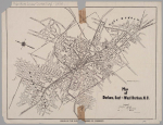 | Map of Durham, East and West Durham, N.C. A 1924 Durham Chamber of Commerce map depicting schools, mills, factories, and cemeteries in Durham. This map contains information pertaining to neighborhoods now commonly referred to as: West End, Lyon Park, West Durham (area surrounding Erwin Mills), Pearl Cotton Mills Village, Duke University (East Campus), Trinity Heights, Walltown, Trinity Park, Old North Durham, Morehead Hill, Duke Park, Downtown Durham (Central Business District), Cleveland-Holloway Street, East End, East Durham (portion), Edgemont and Morning Glory near the Golden Belt Manufacturing Company, Hayti. The map identifies street names and the location of hydrants, fire alarm boxes and fire stations. | |
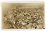 | Aerial photograph of Durham looking toward the Northwest This aerial view of downtown Durham was taken prior to the completion of the Washington Duke Hotel (ciirca 1925). In the foreground on Main Street are the First Presbyterian Church and Durham County Courthouse. The view also shows Union Station, Liggett & Myers and Imperial Tobacco. Durham High School and the Pearl Mill Village are visible in the background. | |
digitaldurham@duke.edu · About this site · Copyright © 2001 - 2006. Trudi J. Abel. All Rights Reserved.
The copyright interest in the material in this digital collection has not been transferred to the Digital Durham project. These text and images may not be used for any commercial purpose without the permission of the David M. Rubenstein Rare Book & Manuscript Library and the Digital Durham Project. Copyright permission for subsequent uses is the responsibility of the user.