Order these records by:
Browse Collection › LC Subject Heading › 4 records found where LC Subject Heading is Textile industry -- North Carolina -- Durham -- 19th century | ||
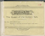 | Durham, the queen of the golden belt An pamphlet created by Durham Consolidated Land and Improvement Company to promote investment in businesses and real estate in Durham, North Carolina. Includes three lithographs of buildings in Durham: Main Building at Trinity College; West End Cotton Factory; and Wescarr Knitting Mill. Durham is described as a sophisticated town with well-developed industrial, commercial, and residential districts for: plants, mills, factories, railroad stations and tracks, banking facilities, schools, churches, and colleges. | |
 | Hand-book of Durham, North Carolina : a brief and accurate description of a prosperous and growing southern manufacturing town This pocket-sized handbook documents the people, businesses, social conditions, and government of Durham, North Carolina, and compares Durham's industrial and social advantages to other cities of the same size. It includes statistical records and information about Durham's government, health, real estate, taxes, buildings, streets, waterworks, fire departments, electric lights and gas, telephones, hotels, hospitals, markets, schools and colleges, churches, lodges, and social clubs. Included are lithographs of Mangum Street and Main Street and depictions of prominent buildings, such as: Bennett Place; Durham County Court House; the Fire House; Hotel Carolina; City Hospital; Durham Graded School; Trinity College's Main Building; Trinity Methodist Church; Main Street Methodist Church; the Presbyterian Church; the First and Second Baptist Church; bank buildings; the factory of the Blackwell Durham Tobacco Co.; Duke Tobacco Factory; and textile factories. Portraits include Isaac N. Link, ma... | |
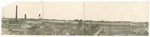 | Panoramic photograph of Erwin Cotton Mills with mill housing Holladay Studio photographed Erwin Cotton Mills and the company's housing for its employees, which is located nearby the mill. | |
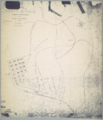 | Map of the town of North Durham: property of B. L. Duke and its relative position to Durham, North Carolina An 1890 map showing the property owned by Brodie Leonidas Duke in Durham, North Carolina, just east of Trinity College, in an area now identified as Trinity Park. The map also provides names of downtown streets, shows the location of Bobbin & Shuttle Mills, fertilizer factory, cotton factory and railroad lines. Scale 400 feet to 1 inch or [ca.1:4800]. | |
digitaldurham@duke.edu · About this site · Copyright © 2001 - 2006. Trudi J. Abel. All Rights Reserved.
The copyright interest in the material in this digital collection has not been transferred to the Digital Durham project. These text and images may not be used for any commercial purpose without the permission of the David M. Rubenstein Rare Book & Manuscript Library and the Digital Durham Project. Copyright permission for subsequent uses is the responsibility of the user.